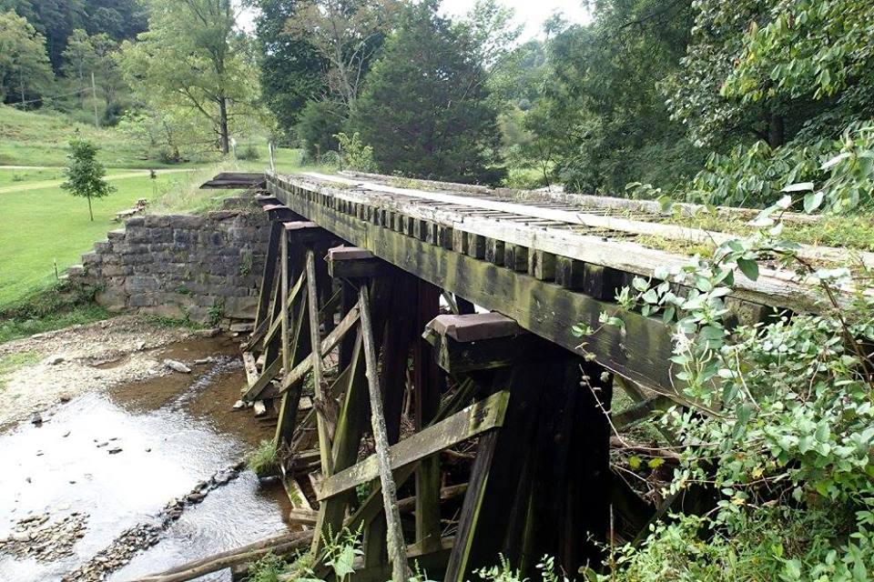
---------------------------------------------------------------------------------------------------------------------------------------------- | Trestle # | Height | Length | approx. GPS Location | Comments | Near | [Decking Cost Actual] | | (open = *)| | | | | | ($Estimate/ $550/ft) | ---------------------------------------------------------------------------------------------------------------------------------------------- | 1 | | | | | | | | Tindall * | 14' 2" | 67' 8" | 36.62440 (36°37’28”N) | At Evans Drive underpass | 130 Wagner Road | [ $38,000 Decking ] | | | | | -82.19503 (82°11’42”W) | near Bristol Trailhead | Bristol VA 24202 | | | | | | | | | | ---------------------------------------------------------------------------------------------------------------------------------------------- | (2) * | | | | | | | | Campground| (30' ?) | (350+'guess)| 36.63196 (36°37’55”N) |over creek & Campground Rd| Campground Road | ( $$$$$$ Estimate) | | Road | | | -82.19502 (82°11’42”W) | -REMOVED-by VDOT 1990's | Bristol VA 24202 | | | | | | | | | | ---------------------------------------------------------------------------------------------------------------------------------------------- | 3 | | | | | | | | Benhams | 39' 0" | 192' 6" | 36.67251 (36°40’21”N) | Large Benhams trestle | 7514 Rich Valley Road | ($105,600 / $550/ft) | | High * | | | -82.22155 (82°13’17”W) | Stringers 2'3"x 1'3" | Bristol VA 24202 | | | | | | | | | | ---------------------------------------------------------------------------------------------------------------------------------------------- | 4 | | | | | | | | Benhams | 17' 2" | 121' 5" | 36.67844 (36°40’42”N) | Drive under Benhams | 18306 Benhams Road | ($67,000 / $550/ft) | | Crossing *| | | -82.21828 (82°13’6”W) | trestle. Steel center | Bristol VA 24202 | $101,284 | | | | | | | | | ---------------------------------------------------------------------------------------------------------------------------------------------- | 5 | | | | | | | | Gum Hill | 14' 9" | 68' 10" | 36.68747 (36°41’15”N) | Gum Hill Rd. Drive under | 7371 Gum Hill Road | ($38,000 / $550/ft) | | Crossing | | | -82.22600 (82°13’34”W) | trestle at Wolf Run | Bristol VA 24202 | $67,808 | | | | | | on left | | | ---------------------------------------------------------------------------------------------------------------------------------------------- | 6 | | | | | | | | | 9' 2" | 41' 10" | 36.69300 (36°41’35”N) | Decked for driveway | 7136 Wolf Run Road | ($22,550 / $550/ft) | | | | | -82.23233 (82°13’56”W) | off Wolf Run Road | Bristol VA 24202 | $64,558 | | | | | | on left | | | ---------------------------------------------------------------------------------------------------------------------------------------------- | 7 | | | | | | | | | 8' 3" | 34' 6" | 36.69385 (36°41’38”N) | medium length. on right | Wolf Run Road | ($18,700 / $550/ft) | | | | | -82.23383 (82°14’2”W) | off Wolf Run Road | Bristol VA 24202 | $58,639 | | | | | | | | | ---------------------------------------------------------------------------------------------------------------------------------------------- | 8 | | | | | | | | | 20' 0" | 122' 7" | 36.69803 (36°41’42”N) | long. on right | Wolf Run Road | ($67,000 / $550/ft) | | | | | -82.23559 (82°14’8”W) | off Wolf Run Road | Bristol VA 24202 | $125,699 | | | | | | | | | ---------------------------------------------------------------------------------------------------------------------------------------------- | 9 | | | | decked for driving | | | | | 9' 4" | 55' 3" | 36.69803 (36°41’53”N) | next to old barn | 6259 Wolf Run Road | ($30,000 / $550/ft) | | | | | -82.24528 (82°14’43”W) | off Wolf Run Road | Bristol VA 24202 | $75,375 | | | | | | on right | | | ---------------------------------------------------------------------------------------------------------------------------------------------- | 10 | | | | shortest trestle. on left| | | | Leonard | 7' 11" | 14' 4" | 36.69685 (36°41’49”N) | decked for driving. | 6176 Wolf Run Road | ( $7,700 / $550/ft) | | Station | | | -82.24725 (82°14’50”W) | off Wolf Run Road | Bristol VA 24202 | | | | | | | | | | ---------------------------------------------------------------------------------------------------------------------------------------------- | 11 * | | | | | | | | | 7' ?" | 57' ?" | 36.69414 (36°41’39”N) | past Wolf Run Road end | | ($31,000 / $550/ft) | | | | | -82.25640 (82°15’23”W) | along Wolf Run Creek | Bristol VA 24202 | $80,845 | | | | | | | | | ---------------------------------------------------------------------------------------------------------------------------------------------- | 12 * | | | | | | | | | 7' ?" | 51' ?" | 36.69244 (36°41’33”N) | along Wolf Run Creek | | ($28,000 / $550/ft) | | | | | -82.25979 (82°15’35”W) | | Bristol VA 24202 | $61,036 | | | | | | | | | ---------------------------------------------------------------------------------------------------------------------------------------------- | 13 * | | | | | | | | | 13' 4" | 84' 0" | 36.68930 (36°41’22”N) | along Wolf Run Creek | | ($61,000 Estimate) | | | | | -82.26445 (82°15’5”W) | Missing support | Bristol VA 24202 | $104,236 | | | | | | | | | ---------------------------------------------------------------------------------------------------------------------------------------------- | 14 * | | | | | | | | side creek| 10' 0" | 71' 4" | 36.68703 (36°41’13”N) | along Wolf Run Creek | Phillips | ($51,000 Estimate) | | | | | -82.26504 (82°15’35”W) | Missing abuttment | Bristol VA 24202 | $74,627 | | | | | | | | | ---------------------------------------------------------------------------------------------------------------------------------------------- | 15 * | | | | | | | | | 11' 7" | 55' 6" | 36.68305 (36°40’59”N) | along Wolf Run Creek | 18105 Phillips Road | ($34,000 Estimate) | | | | | -82.27065 (81°16’14”W) | | Bristol VA 24202 | $69,942 | | | | | | | | | ---------------------------------------------------------------------------------------------------------------------------------------------- | (16) * | | (294' | | | | | | Little |(123?' 6?")| original | 36.69073 (36°41’27”N) | over Abrams Creek & road | 17430 Hollis Lane | ( $$$$$$ Estimate) | | Wolf Run | | 160' filled | -82.28395 (82°17’2”W) |-REMOVED-by VDOT in 1990's| Bristol VA 24202 | | | | | in in 1940) | | | | | ---------------------------------------------------------------------------------------------------------------------------------------------- | 17 | | | | | | | | Abrams * | 10' 8" | 82' 6" | 36.69311 (36°41’35”N) | Decked for driving | 17141 Hollis Lane | ($45,000 / $550/ft) | | Creek | | | -82.28922 (82°17’21”W) | over Abrams Creek | Bristol VA 24202 | $73,800 | | | | | | Missing support | | | ---------------------------------------------------------------------------------------------------------------------------------------------- | 18 | | | | | | | | Wildwood *| 19' 2" | 82' 6" | 36.69493 (36°41’42”N) | north of of Hollis | 17121 Hollis Lane | ($45,000 / $550/ft) | | | | | -82.29351 (82°17’37”W) | over Abrams Creek | Bristol VA 24202 | | | | | | | | | | ---------------------------------------------------------------------------------------------------------------------------------------------- | 19 | | | | Steel Girder trestle | | | | Sunnyside | 26' 9" | 276' 11" | 36.69478 (36°41’42”N) | one mile S. of Mendota | 3246 Civil Drive | ($152,000 / $550/ft) | | Holston | | | -82.29663 (82°17’48”W) | over N. Holston River | Mendota VA 24270 | $185,094 | | River * | | | | parallel swinging bridge | | | ---------------------------------------------------------------------------------------------------------------------------------------------- | Trestle # | Height | Length | GPS Location | Comments | Near | [Decking Cost Actual] | | (open = *)| | | | | | ($Estimate/ $550/ft) | ----------------------------------------------------------------------------------------------------------------------------------------------
All Mendota Trail trestles are constructed with the classic timber construction with the exception of #19 which is a steel girder
with one timber end ~40 foot and Benhams #4 which has a steel center passing over the road.
These trestles and abutments were built more robust than some railroad to meet the heavier loads requirements of coal trains.
The age of any specific trestle is unknown with the exception of the 1905 date plaque over the Holston River trestle.
This route first belonged and built by the Bristol Coal and Iron Narrow Gauge Railroad Co,
passenger and freight service began in May 1890 and flourished on this line, now called the South Atlantic and Ohio Railway (1890)
or the Virginia and Southwestern Railway (1899), until service as Southern Railway (U.S.) ceased in 1972.
A trestle is a bridge that consists of a number of short spans, supported by splayed vertical elements
and is usually for railroad use. A bridge is a structure built to span a gorge, valley, road, railroad track,
river, body of water, or any other physical obstacle.
Trestle: short spans. Bridge: all the way across.
For our purposes here, we just call everything a trestle.